Queensland underground data reshapes our understanding of tectonic plate stress
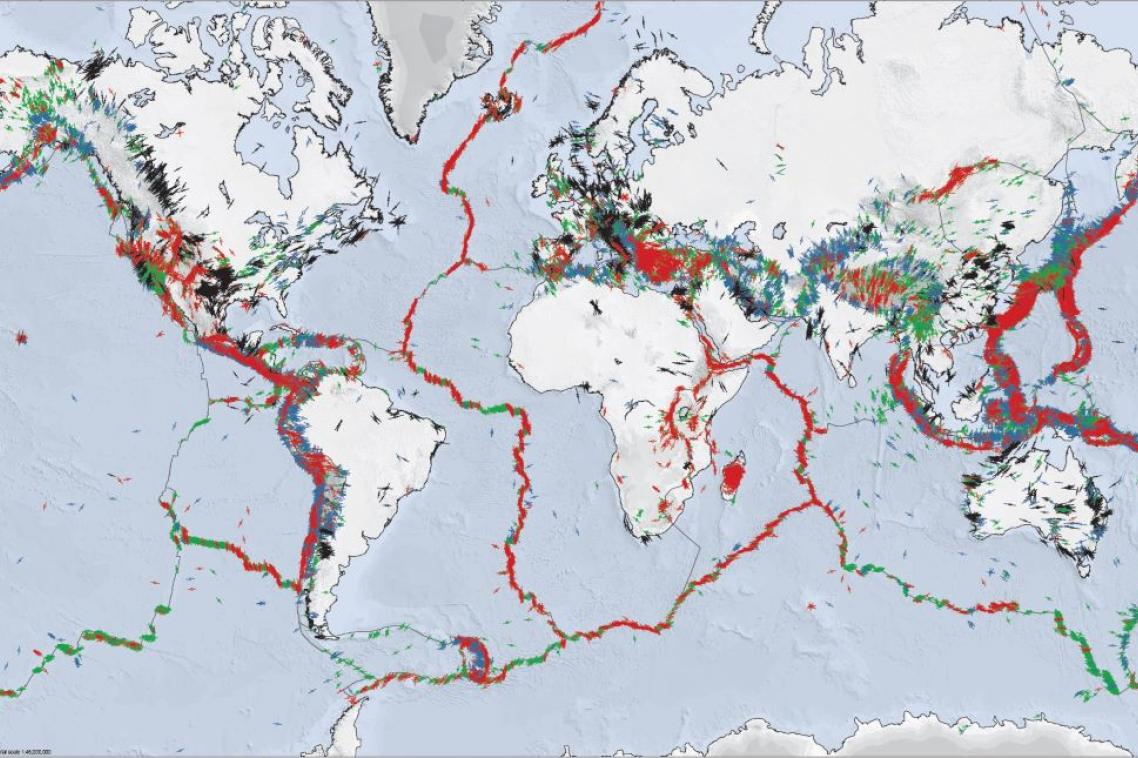
The map shows underground points of stress in the Earth's crust.
(Photo credit: The World Stress Map Project )
The Earth’s underground stress patterns have been mapped in more detail than ever before, through a University of Queensland and GFZ Helmholtz Centre for Geosciences collaboration.
The World Stress Map is a long-term international scientific project to increase understanding of earthquakes and how stress builds beneath the Earth’s surface.
Dr Mojtaba Rajabi from UQ’s School of the Environment said the latest update to the map could help make underground mining and construction activities safer by providing better insights into the Earth’s stress conditions.
“Earthquakes don’t always come from nature, sometimes we cause them,” Dr Rajabi said
“Digging, drilling, or injecting fluids in the wrong spot can tip the underground balance and induce a seismic event. Understanding stress helps us prevent these man-made shakes.
“The new data reveals how both large tectonic forces and local geology influence the stress within the Earth’s crust, which is crucial knowledge for understanding earthquakes.”
Dr Rajabi said Australia held a few geological surprises, which had puzzled scientists for more than 30 years.
“Australia’s underground stress patterns are unlike any other continent, highly variable, full of twists and turns, and not aligned with the direction the continent is moving,” Dr Rajabi said.
“We once thought tectonic plate forces and continental-scale geological structures were the main drivers of stress orientation within continents, but new data from eastern Australia shows rock types, density variations, and localised geological structures can have an even greater influence.
“This finding suggests where the geology is more complex, the stress pattern is too.”
(Photo credit: The University of Queensland)
Data from central Queensland’s mining heartland, the Bowen Basin, revealed a dramatic rotation in underground stress of more than 50 degrees within 100 kilometres.
“The direction of the tectonic force coming from the plates east of Australia change dramatically and when these forces interact with local geological conditions, they redirect stress in different ways,” Dr Rajabi said.
“As a result, the safest directions for drilling and or excavation can vary significantly between locations in the same region.
“With this level of detail, we can now better understand how tectonic forces behave not just across regions but at the local scale too.
“The more data we have, the more we understand the causes and consequence of the Earth’s tectonic forces.
“Australia plays a leading role in this global effort thanks to the open availability of borehole data and strong collaboration across sectors.”
The World Stress Map has been updated every decade for over 40 years, drawing on data from seismology centres, the energy and resources sector, and civil engineering projects across the globe.
The latest update includes more than 100,000 stress data records and is designed to be a vital tool for industries and researchers working to ensure the safe use of the Earth’s subsurface.
The map is freely available online.
Related articles

Meet the UQ hackers fighting to lift the 'world cup of cyber'
